Down Up Stop Top

SHORT TERM FORECAST
NATIONAL WEATHER SERVICE MELBOURNE FL
604 PM EDT FRI SEP 5 2008
AMZ550-552-555-570-572-575-FLZ041-044>047-053-054-058-059-064-141-
144-147-052330-
COASTAL VOLUSIA-FLAGLER BEACH TO VOLUSIA-
BREVARD COUNTY LINE 20 NM TO 60 NM OFFSHORE-FLAGLER BEACH TO VOLUSIA-
BREVARD COUNTY LINE OUT TO 20 NM-INDIAN RIVER-INLAND VOLUSIA-MARTIN-
NORTHERN BREVARD-NORTHERN LAKE-OKEECHOBEE-ORANGE-OSCEOLA-
SEBASTIAN INLET TO JUPITER INLET 20 NM TO 60 NM OFFSHORE-
SEBASTIAN INLET TO JUPITER INLET OUT TO 20 NM-SEMINOLE-
SOUTHERN BREVARD-SOUTHERN LAKE-ST. LUCIE-VOLUSIA-
BREVARD COUNTY LINE TO SEBASTIAN INLET 20 NM TO 60 NM OFFSHORE-
VOLUSIA-BREVARD COUNTY LINE TO SEBASTIAN INLET OUT TO 20 NM-
604 PM EDT FRI SEP 5 2008
.NOW...
THE OUTERMOST RAINBANDS OF TROPICAL STORM HANNA WILL PRODUCE ISOLATED
SHOWERS ACROSS EAST CENTRAL FLORIDA INTO THE EVENING HOURS AS HANNA
PULLS UP THE EASTERN SEABOARD. THESE SHOWERS WILL PRODUCE BRIEF
PERIODS OF MODERATE TO HEAVY RAIN AS THEY MOVE EAST-SOUTHEAST AT 20
TO 25 MPH.

Record high temperature 97.2°F Record low temperature 31.3°F Record high gust 79.0 mph Record high average 50.3 mph Record daily rain 4.69 in. Record low windchill 21.6°F Record high barometer 30.629 in. Record low barometer 29.332 in.
Daily high pressure 29.748 in. Daily low pressure 29.584 in. Daily low windchill 75.4°F Daily high heat index 93.9°F Daily high gust speed 29.0 mph WNW Daily high average speed 21.6 mph NW
Weather Data, St.Cloud, Florida
LAST READING AT TIME: 7:30 PM DATE: September 05 2008 ,Time of next update: 8:00 PM
Current WeatherDusk/Dry/Dry Current Temperature 82.0°F (27.8°C) (Heat Index 88.8°F ), Apparent temp 88.9°F , Apparent temp solar 88.9 °F
Maximum Temperature (since midnight)84.8°F at: 5:12 PM Minimum Temperature (since midnight)75.4°F at: 6:53 AM
Average windspeed (ten minute)3.0 mph Wind Direction (ten minute)WSW (257°)
Heat Index 88.8°F Maximum Gust (last hour)12.0 mph at: 7:06PM
Maximum Gust (since midnight)29.0 mph at: 9:28 AM Maximum 1 minute average (since midnight)21.6 mph at: 9:28 AM
Rainfall (last hour)0.00 in. (0.0 mm) Rainfall (since midnight)0.08 in. (2.0 mm) at 11:36 AM
Rainfall This month 0.10 in. (2.5 mm) Rainfall To date this year 38.45 in. (976.7 mm)
Maximum rain per minute (last hour)0.00 in/min Maximum rain per hour (last 6 hours)0.00 in/hour
Yesterdays rainfall 0.00 in DewPoint 75.2°F (Wet Bulb :77.3°F )
Humidity 80 %, Humidex 102.3°F Barometer corrected to msl29.747 in. (1007.4 hPa)
Pressure change +0.02 in. (last hour) Trend (last hour)RISING SLOWLY
Pressure change (last 12 hours)+0.14 in Pressure change (last 6 hours)+0.07 in
Current Indoor temp. 83.3°F
Current Indoor hum. 42%
Current solar 0 W/M² Current UV0.0
Maximum solar (since midnight) 679 W/M² Maximum UV (since midnight) 7
Current 00:00 hours of sunshine today, current sky: Dusk/Dry
Sunshine hours for the year: 518:31 hrs Sunshine hours for the month: 06:48 hrs
Current evapotranspiration 0.16 inches per day. Yesterday's reading 0.23
Lightning counts 0 since noon
Time of last strike 20:16:40 2008/08/30Counts in the last 30 minutes 0

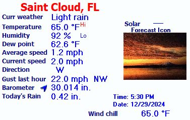
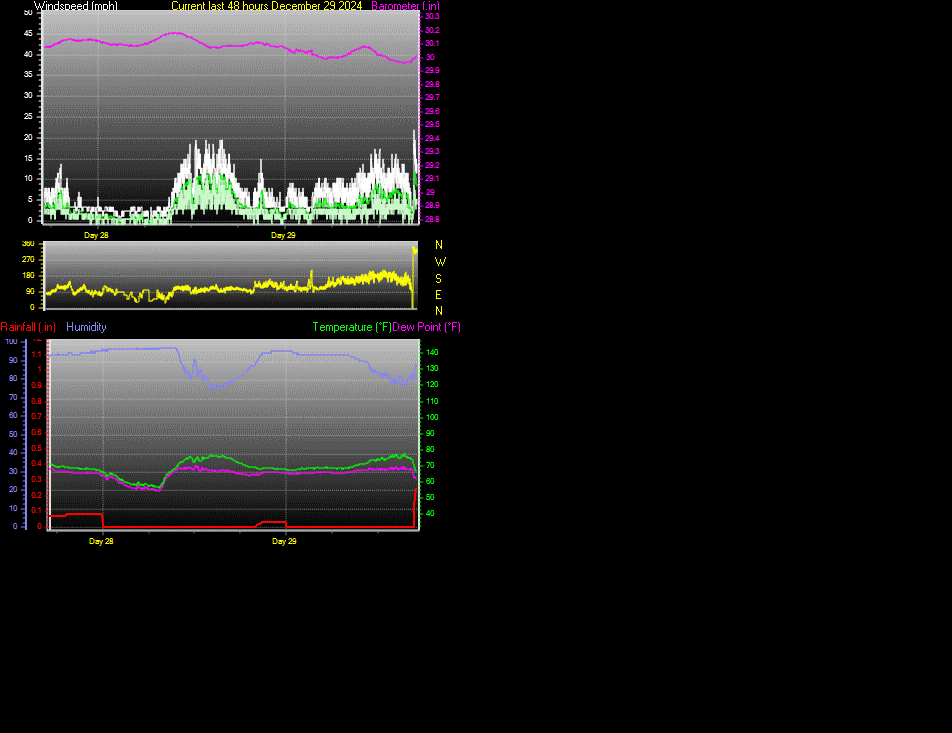
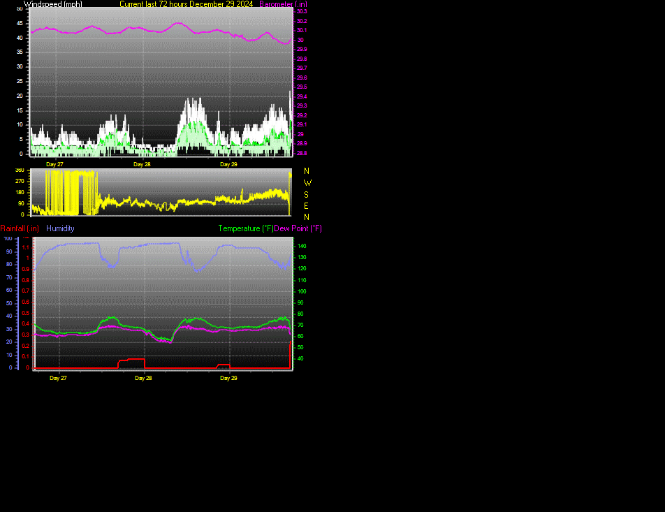
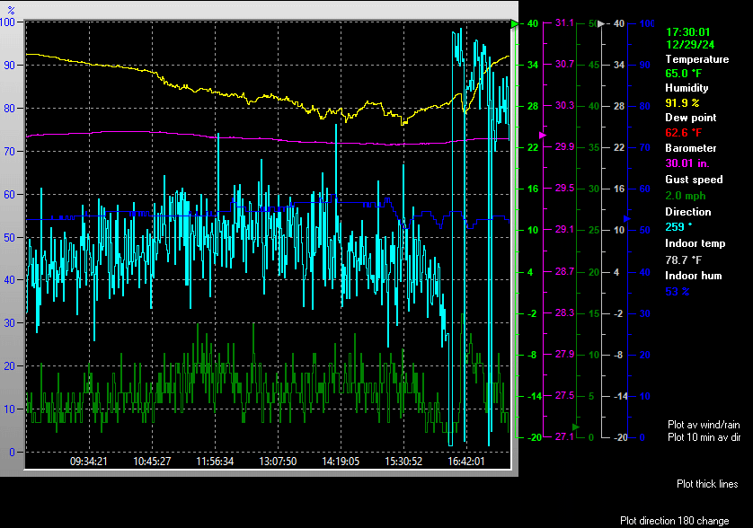
This page is updated from recent data collected by a DAVIS VANTAGE PRO weather station Use the Reload or Refresh facility on your browser to retrieve the latest data.


Latest Web Cam Image


The data is logged at two minute intervals, but there is data recorded every minute.

Use the RELOAD facility on your browser to retrieve the latest data.

Daily Fire weather Index for this station
Click here for a daily update of the averages/extremes to date for the month


Created by "Weather Display" software version 10.37L at this start time/date 10:14:01 PM 09/04/08